


Why Does Border Security Matter?
In the middle of the excitement surrounding the 2024 Prime Ministerial election in India, let’s consider: In the constantly shifting geopolitical landscape, what are the fundamental needs that drive our nation to progress? Could ensuring safety and security across the borders be one of them?
India’s borders with its neighbours were variably established at the time of its independence. While some borders were drawn on the ground, others were merely marked on maps, and some others had no formal boundaries at all. The effects of that are still resonating throughout India. And this strengthens India’s case for why it should be a major priority for us to integrate technology into defence.
Imagine national security as a puzzle. At its core lies the national security strategy, the blueprint that guides nations through the twists and turns of global uncertainty. Governments must be one step ahead of potential dangers by anticipating them, taking preventative measures, and acting quickly to address them. Developing a solid national security policy requires more than simply defence; it also requires intelligence, adaptability, and being prepared to take advantage of opportunities and mitigate dangers.
Why Geospatial Analysis for Border Surveillance?
Managing borders, at sea or land and ports or airports, is a completely different strategic game. Consider it this way: time is the key in ports and airports as everything must happen swiftly. However, the primary difficulty in discussing borderlands is space – ensuring that we have control over all of that territory.
India’s borders cover 15,000 km and cover a variety of topographies, including plains, mountains, forests, and deserts. The abundance of terminology in this discipline presents numerous challenges:
- This diverse topography challenges the application of conventional surveillance techniques as it is often difficult to even physically reach the affected area with given time and environment constraints.
- Across such large and complicated areas, traditional surveillance finds it difficult to guarantee thorough coverage and give right answers at the right time.
- Cross-border criminal incidents such as human trafficking, terrorism and smuggling, which require constant monitoring, are still out of control.
In this context, utilising the potential of geographic and spatial data can be a game-changer.
The process of gathering geographic data from multiple sources like, GPS, satellite imagery, unmanned aerial vehicle (UAV) photography, geographic information systems (GIS), and other sensors, followed by modifying, and analysing them strategically is altogether Geospatial data analysis. Governments and security organisations can obtain crucial insights about border regions by using this wealth of spatial data over time. This strategic approach can help them to recognise new patterns, spot irregularities, and react quickly and accurately to dangers.
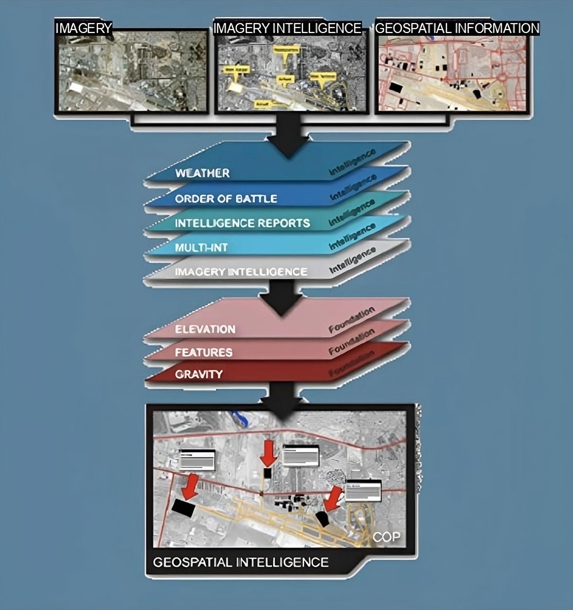
In fact, the phrase geospatial intelligence (GEOINT) [7], having originated in the United States, is now universally recognised. Indo Pacific Geointelligence Forum, an upcoming conference in India, highlights the nation’s growing dedication to advancing geospatial awareness. With a thematic focus on fostering resilient multidomain regional security across land, sea, air, space, and cyberspace, this event serves as a prime example of India’s proactive steps towards strengthening its geospatial strategic capabilities.
GEOINT basically represents a multifaceted discipline that integrates the acquisition, analysis, and interpretation of data about the Earth’s surface. The conventional approach of GEOINT is depicted in the figure below taken from [1]. By synthesising information from multiple sources, GEOINT provides a wholesome understanding of spatial dynamics and thus facilitates informed decision-making across a spectrum of domains, including defence, urban planning, disaster response, and resource management.
Geospatial Data Acquisition
Geospatial data of India and surroundings can be obtained from various sources, both governmental and non-governmental. The most popular and authentic sources are listed below:
- Survey of India (SOI): The Survey of India [2] is the national mapping agency of India, responsible for surveying and mapping the country’s terrain. It provides topographic maps, cadastral maps, and other geospatial datasets covering different regions of India.
- National Remote Sensing Centre (NRSC): NRSC [3] is a part of the Indian Space Research Organisation (ISRO) and is responsible for satellite remote sensing. It offers satellite imagery and remote sensing data for various applications, including agriculture, forestry, water resources, and urban planning. The two very admirable and helpful websites, Bhuvan [5] and Bhoonidhi [6], were made by the NRSC and are available for viewing and downloading satellite data. Along with other geospatial services, Bhuvan offers satellite imagery and themed maps. Through the use of bespoke maps made for particular areas of interest, users can access high-resolution satellite imagery. Additional access to the vast collection of remote sensing data from 44 satellites, including foreign and Indian sensors collected since 1986, can be gained through Bhoonidhi. Moreover, it makes Sentinel and LandSat (8 & 9) data regional distribution in India easier.
- National Spatial Data Infrastructure (NSDI): NSDI is an initiative aimed at creating a framework for sharing geospatial data across different government agencies and departments. It facilitates the discovery, access, and exchange of spatial data from various sources, promoting interoperability and standardisation.
- State Government Departments: Many state governments in India maintain their own geospatial databases and mapping services. For example, J&K, Punjab, West Bengal, Karnataka, Kerala, Delhi, Haryana, Jharkhand, Odisha, Uttarakhand have launched their own geoportal services. These state-level agencies are mainly responsible for land records, urban planning, natural resource management, and disaster management but are often likely to provide geospatial data for their respective regions.
Anticipating Threats through Geospatial Data Analytics
- Requisites
In the world of defence intelligence, we use some technology, called geographic information systems (GIS) [9] to gather and process important info about hotspots. This helps us build smart defence strategies against situations that could threaten public safety and national security. But there’s a trick: our GIS setup needs to be top-notch, able to handle quick-changing missions for both border and internal security. Let’s imagine them as versatile tools in a toolkit – agile (able to adapt and change on the fly), flexible (able to grow or shrink as needed), and super easy to use (so our operational folks can navigate and get things done). With the right GIS setup, we’re ready to handle any challenge that comes our way and keep our borders safe and secure!
- Data Preprocessing
Now, let’s discuss the often overlooked step of data preprocessing, which should be the foundation for any analytical framework. In specific to geospatial data analysis, the key focus should be on building Analysis Ready Data (ARD) [8]. This process involves integrating diverse data sources and refining them to a point where they’re ready to be analysed. ARD not only streamlines the flow of data but also serves as the launchpad for all subsequent analytical endeavours. It basically refers to satellite or remote-sensing data that have been pre-processed to a certain level and formatted to be readily usable for analysis without the need for further basic preprocessing or calibration. ARD typically undergo various steps of processing, including noise detection, radiometric and geometric corrections, atmospheric correction cloud masking etc. to ensure that the data are consistent, accurate, and free from artefacts that could be problematic in the analysis tasks such as image classification, change detection, or time-series analysis.
- Predictive Analytics
In defence strategies, anticipating battlespace, potential conflicts or enemy movements is the key. This is the task of predictive analytics, allowing us to take preemptive measures. We have numerous efficient tricks up our sleeves. For example, ever wondered how we figure out the elevation of places we’ve never been to? Spatial interpolation plays a significant role in it by estimating heights based on what’s around. Then there is spatial regression, which unfolds the hidden relationships between neighbouring places. Another approach is point pattern analysis, a nifty tool for spotting clusters or patterns in the data, whether they’re grouped tightly together or spread out evenly. These methods help us to reveal a secret map that brings the hidden stories in our world.
But an additional subject that sets this apart from other use cases of geospatial analysis is Situational Awareness, a vital concept that gives us a real-time understanding and control over what’s happening on the ground. To achieve this, advanced technologies like GeoAI that involve machine learning and artificial intelligence, come into play. Geospatial machine learning uses historical data to forecast how areas might evolve in the future. Meanwhile, analysing images and videos captured by aerial vehicles and satellites provides crucial insights. Additionally, routing and logistics optimization algorithms help to solve spatial network challenges and in turn ensure efficient movement and response. With these cutting-edge tools, we’re not just predicting the future – we’re going to shape it. For example, in recent GeoAI updates of ESRI [10], it mentioned how aerial imagery is used to extract imagery of buildings and roads in Grenada to identify the potentially risky population and infrastructure for landslides.
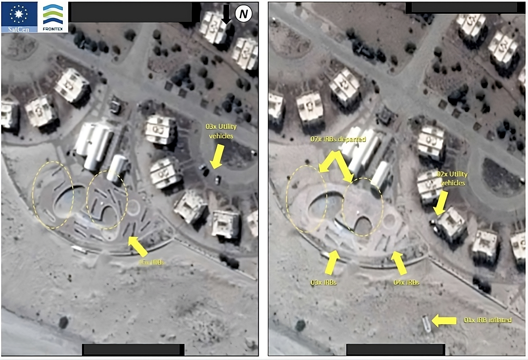
Now have a look at the below picture which is taken from [1]. This satellite image of the same place at different time stamps reveals striking changes – the appearance and disappearance of troops and infrastructures. This observation uncovers patterns that may help to identify groups of suspects and map out potential smuggling routes, or even pinpoint exact crossing points. We’re majorly looking out for vehicles, groups of people, or even specific behaviours, known as MO (modus operandi) in these analyses.
- Real Time Intelligence & Decision-Making
GEOINT acts as a crucial early warning system for safeguarding national security. As described in the previous section, by keeping a close eye on changes in the physical surroundings, like vehicle movement or infrastructure shift, policymakers can spot potential threats before they become a full-blown crisis. Using this technology, policymakers can gain access to comprehensive and accurate data about our environment which help them to make smarter decisions to protect our nation. This enhanced awareness doesn’t just stop at spotting threats; it also helps policymakers to understand the risks and opportunities in our surroundings. With this knowledge, they can develop effective strategies to counter any threats to national security. And during times of crisis or emergencies, GEOINT’s real-time information can become a lifeline.
But it gets even more exciting when the power of AI takes GEOINT to a whole new level. With AI-driven geospatial tools, commanders and decision-makers can access live feeds and instant analysis. This means they can adapt and respond to evolving situations with agility and precision, revolutionising our defence and security decision-making processes.
- Requisites
Smart Borders: Opening, Integrating and Simplifying Everything
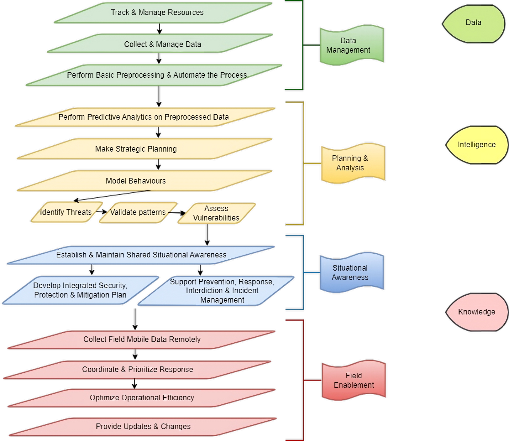
After diving into all these technologies and needs, there’s still one burning question in our minds: How do we make this whole process seamless? Well, I’ve got an idea inspired by the functionality of the ESRI GIS tools [11]. The figure below describes an outline of the process of converting raw data into knowledge through intelligence.
GeoAI: Being Smarter
Now let’s dive deeper into GeoAI. GeoAI helps us overcome major obstacles like never before:
- Improve data quality, consistency, and accuracy : Simplifies human data generating processes by leveraging automation to boost productivity and cut expenses.
- Accelerate the time to situational awareness: In order to facilitate lesser reaction times and proactive decision-making during the field enablement phase, it can monitor and analyse events, assets, and entities using multiple sensors and sources together, including video.
- Bring location intelligence to decision-making: Able to make informed decisions combining data and practical experience. Using precise predictions and geographical pattern analysis, it also improves decision making.
VII. Case Study – India China Border Dynamics
Now that we’ve got a good understanding of how a smart border management system works, let’s zoom in on one of the most intriguing and high-stakes borders in the world, the India-China border. China, being India’s most technologically advanced and diplomatically significant neighbour, makes this border especially interesting.
- Is it Really Serious?
During recent Lok Sabha election campaigns, Congress president Mallikarjun Kharge accused China of sneaking into Indian territory, building houses and roads there [12] . The Times of India reports [13] that even four years into the face-off in eastern Ladakh, China hasn’t let up. They’re building dual-use ‘Xiaokang’ villages, strengthening military positions, and deploying more aircraft at air-bases facing India. Sounds pretty intense, right?
- Data Management & Data
Satellite imagery is the most valuable data for identifying threats and comprehending their extent. The technology involved within the spectrum of satellite imagery analysis offers unparalleled insight into the evolving dynamics of a given space over time, allowing for a comprehensive understanding of the situation at hand. For this purpose different data sources as mentioned earlier in this article are to be synchronised with each other to get the real hidden information using data from different angles and dimensions.
- Intelligence
A recent study by Takshashila Institution digs deep into the Indo-China border settlements and potential threats . It reveals China’s strategic construction of settlements along the Line of Actual Control (LAC) with India. While China claims these settlements are for poverty alleviation, they also boost surveillance, assert territorial claims, and support military operations, especially in the Tibet Autonomous Region.
Using advanced remote sensing tools, the research maps settlements within 100 km of the LAC in Arunachal Pradesh. Major clusters are near highways and water bodies, suggesting strategic placement for military and resource advantages. Key developments include new residential areas near the G219 highway at Chayal and redevelopments in Jamchen. Strategic sites like Kone County and the Rorong Settlement feature dual-purpose structures for both civilian and military use. The expansion is deliberate, reflecting China’s goal to control territory through infrastructure. Notable findings include messages like “We must win the war” and “Follow the CCP’s command, win the war, we are the best” written on mountain walls.
This research shows how intelligence can bring together info from multiple data sources. Continuous monitoring with remote sensing tech is crucial for validating these settlement patterns and understanding their geopolitical implications.
But the most important step which is to be included with this research to put this into deployment is the shared situational awareness and field enablement.
- Situational Awareness
To tackle this issue effectively, everyone needs to be on the same page, including the military, government agencies, and local authorities. Here’s how we can make that happen:
- Real-Time Data Sharing: Use platforms that provide real-time updates from satellite imagery, drones, and other surveillance tools to keep everyone informed.
- Collaborative Platforms: Create a central command system where data from various sources is integrated and analysed. This allows for coordinated responses to any developments.
- Training and Simulation Exercises: Regularly conduct drills and simulations to prepare for potential scenarios based on the gathered intelligence.
- Field Enablement
Field enablement means giving the people on the ground the tools and info they need to respond effectively. This includes:
- Advanced Surveillance Technology: Equip field units with high-resolution imagery, portable drones, and other surveillance gear to boost their on-ground capabilities.
- Mobile Command Centers: Deploy mobile units with the latest communication and data processing tech to ensure field units can operate independently and make informed decisions.
- Field Intelligence Units: Set up specialised units to gather on-the-ground intelligence and verify info from remote sensing tools. These units would work closely with local populations to gain insights and foster cooperation.
- Infrastructure Development: Build and maintain roads, helipads, and other critical infrastructure to ensure rapid deployment and supply chain efficiency in remote and strategically important areas.
Integrating shared situational awareness and field enablement strategies with continuous monitoring will provide a robust framework to understand and respond to China’s border settlement activities effectively. This comprehensive approach will help in validating settlement patterns, assessing their geopolitical implications, and ensuring a coordinated and effective response to any threats that may arise.
- Is it Really Serious?
Conclusion:
To conclude, I must say that while integration of AI with geospatial intelligence offers immense potential for enhanced situational awareness and decision-making, challenges such as data privacy, ethical concerns, and technological limitations must be addressed. Leveraging AI alongside emerging technologies and establishing robust ethical frameworks both by government and commercial platforms will be crucial for maximising its benefits while ensuring the objective of ‘Data for Public Good’.
- https://www.esri.com/~/media/files/pdfs/events/gis%20in%20the%20eu/filipe%20paisana%20frontex_locked%20presentation02.pdf?la=en
- https://onlinemaps.surveyofindia.gov.in/Digital_Product_Show.aspx
- https://www.nrsc.gov.in/
- https://www.nsdiclearinghouse.gov.in/erdas-apollo/nsdiportal/index.jsp
- https://bhuvan.nrsc.gov.in/home/index.php
- https://bhoonidhi.nrsc.gov.in/bhoonidhi/home.html
- https://www.satcen.europa.eu/what-we-do/geospatial_intelligence
- https://ceos.org/ard/
- https://www.esri.com/en-us/what-is-gis/overview
- https://www.esri.com/en-us/capabilities/geoai/overview
- https://www.esri.com/en-us/path-to-geospatial-excellence/overview
- https://economictimes.indiatimes.com/news/elections/lok-sabha/india/china-encroached-on-our-land-but-pm-modi-is-silent-mallikarjun-kharge/articleshow/110419005.cms?utm_source=contentofinterest&utm_medium=text&utm_campaign=cppst
- http://timesofindia.indiatimes.com/articleshow/109671610.cms?utm_source=contentofinterest&utm_medium=text&utm_campaign=cppst
- https://geospatialbulletin.takshashila.org.in/p/8-chinas-expansive-frontier-the-rise
Author:
Koesha Sinha


