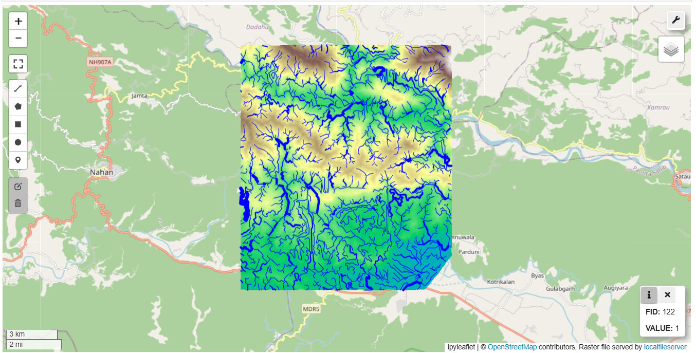
Natural drains act as channels that collect and transport surface water, influencing ecosystems. Mapping these natural drains is essential for understanding the flow of water across a landscape, which has wide-ranging applications in water resource management, flood risk assessment, and environmental protection. To generate natural drains, contour data available for Sirmaur, Himachal Pradesh in the GDI platform was used. Contours represent lines of equal elevation and serve as the foundation for creating a detailed topographical model. As an initial step, a continuous surface raster (Digital Elevation Model) was generated from contour using cubic interpolation method.

Once the DEM was created, a series of hydrological analysis tools were applied using the Whitebox Tools python library. The DEM was first processed through a “fill” operation to remove any depressions that are outliers or noise. After this, flow direction analysis was conducted to determine the direction in which water would move across the landscape, followed by basin generation to identify the individual catchment areas. Flow accumulation was then calculated to determine how water converges and flows across the terrain, with areas of high accumulation indicating the presence of natural drains or streams.
To define the stream network, a threshold value was applied to the flow accumulation results, marking the points where enough water has accumulated to form a stream. The Strahler stream ordering method was then used to classify the streams based on their branching complexity, assigning order numbers to different segments of the stream network. Finally, the stream network was converted from raster format to vector format.
The mapped drains have numerous practical applications. It can aid in identifying areas at risk and source of water pollution, as pollutants often travel along these pathways. It also supports biodiversity conservation by highlighting critical watercourses that support various ecosystems. Moreover, understanding natural drainage patterns is crucial for assessing flood risk, as blocked or altered drainage can exacerbate flooding. Additionally, identifying these natural drains can help locate potential groundwater recharge zones, making this technique invaluable for water resource planning and sustainable development.
Related Posts

- CDPG
- February 28, 2024
Forecasting Kaveri River Water Quality using Time series models
People around the globe, are affected by poor water quality. Potable water scarcity is exacerba ..

- CDPG
- March 21, 2025
Simple Routing – Compute Distance, Duration And Shortest Path Along Road Between Two Points
Routing is an essential component of modern mapping and navigation systems, enabling users to f ..

- CDPG
- December 31, 2023
Profiling Java Applications using Async Profiler and Flame Graphs
Introduction A key requirement of a data exchange is good platform performance. Deciding what i ..


