Comparison of Segmentation Methods in Remote  Sensing for Land Use Land Cover 

Comparison of Segmentation Methods in Remote  Sensing for Land Use Land Cover  
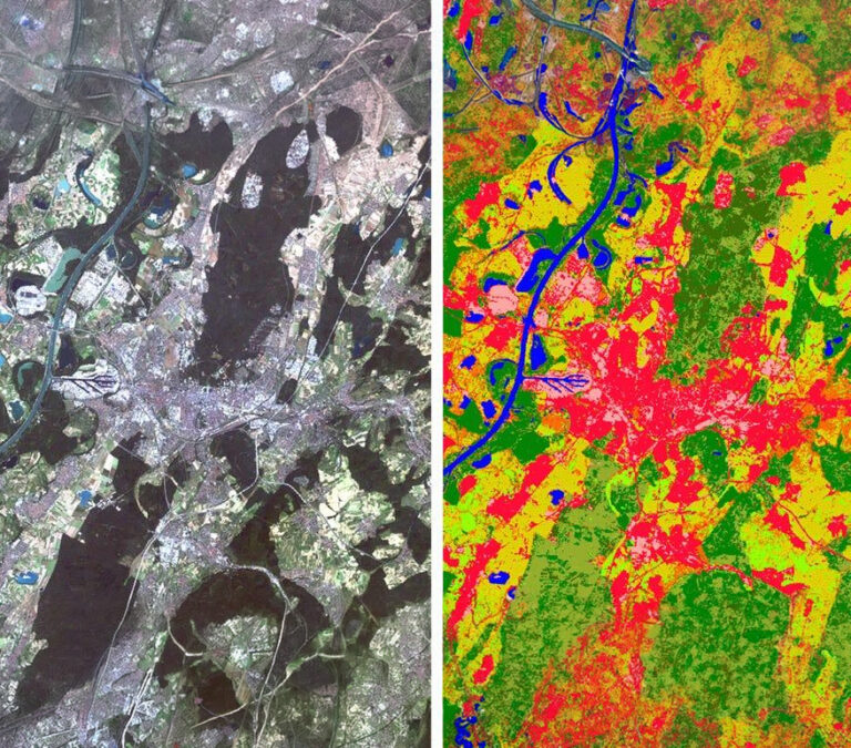
Authors: Naman Srivastava, Joel D Joy,Yash Dixit, Swarup E, Rakshit Ramesh Land Use Land Cover (LULC) mapping is essential for urban and resource planning, and is one of the key elements in developing smart and sustainable this http URL study evaluates advanced LULC mapping techniques, focusing on Look-Up Table (LUT)-based …

Continue Reading

Performance Evaluation of Geospatial Images based on Zarr and Tiff

Nov 2024 Performance Evaluation of Geospatial Images based on Zarr and Tiff Authors: Jaheer khan, Swarup E, Rakshit Ramesh This evaluate the performance of geospatial image processing using two distinct data storage formats: Zarr and TIFF. Geospatial images, converted to numerous applications like environmental monitoring, urban planning, and disaster management. Traditional Tagged Image File Format is mostly used because it …

Continue Reading

Performance Evaluation of Geospatial Images based on Zarr and Tiff

Nov 2024 Performance Evaluation of Geospatial Images based on Zarr and Tiff Authors: Jaheer khan, Swarup E, Rakshit Ramesh This evaluates the performance of geospatial image processing using two distinct data storage formats: Zarr and TIFF. Geospatial images, converted to numerous applications like environmental monitoring, urban planning, and disaster management. Traditional Tagged Image File Format is mostly used because it …

Continue Reading

Cross Pseudo Supervision Framework for Sparsely Labelled Geospatial Images

Aug 2024 Cross Pseudo Supervision Framework for Sparsely Labelled Geospatial Images Authors: Yash Dixit, Naman Srivastava, Joel D Joy, Rohan Olikara, Swarup E, Rakshit Ramesh Land Use Land Cover (LULC) mapping is a vital tool for urban and resource planning, playing a key role in the development of innovative and sustainable cities. This study introduces a semi-supervised segmentation model for …

Continue Reading

An Atmospheric Correction Integrated LULC Segmentation Model for High-Resolution Satellite Imagery

Sep 2024 An Atmospheric Correction Integrated LULC Segmentation Model for High-Resolution Satellite Imagery Authors: Soham Mukherjeea, Yash Dixit, Naman Srivastava, Joel D Joy, Koesha Sinha, Rohan Olikara, Swarup E, Rakshit Ramesh The integration of fine-scale multispectral imagery with deep learning models has revolutionized land use and land cover (LULC) classification. However, the atmospheric effects present in Top-of-Atmosphere sensor measured Digital …

Continue Reading

Enhanced ETA Predictions with T-GCN on Optimized Road Segments

Oct 2024 Enhanced ETA Predictions with T-GCN on Optimized Road Segments Authors: Shivika Sharma, Nandini Mawane, Chetan Kumar Kuraganti, Dhruthick Gowda M, Mayur Taware, Yash Chandrashekhar Dixit, Sahil Mishra, Raghu Krishnapuram and Rakshit Ramesh Accurate Estimated Time of Arrival (ETA) predictions play a critical role in improving the operational efficiency, traffic management, and reliability of services in transit systems. This …

Continue Reading

Data-Driven Solid Waste Management Optimization with Vehicle Routing and Redistribution Strategy

Oct 2024 Data-Driven Solid Waste Management Optimization with Vehicle Routing and Redistribution Strategy Authors: Chetan Kumar Kuraganti, Arun Josephraj, Saanidhya Vats, Amarthya KR, Koesha Sinha, Raghu Krishnapuram and Rakshit Ramesh This paper presents two techniques for optimizing solid waste management (SWM) systems of a city. The first technique involves planning routes for garbage collection vehicles which utilizes the Capacitated Vehicle …

Continue Reading