




Geospatial datasets are becoming easier to access, but access alone does not make them usable. Before relying on a geospatial dataset, users need the contextual information to understand its origin, quality, coverage, and suitability for their intended application (Figure 1). A high-quality geospatial dataset is more than accurate coordinates or detailed imagery, it is accompanied by metadata that makes it self-explanatory. Without this context, even the best datasets can be difficult to interpret and cannot be used with confidence.
This contextual layer is called metadata — “data about data.” It is what turns a dataset from a raw collection of spatial features into a resource that can be discovered, understood, trusted, and reused.
Metadata is only useful when everyone describes datasets in a consistent way. Without a common structure, two organizations may record the same information differently, making datasets difficult to discover or integrate.
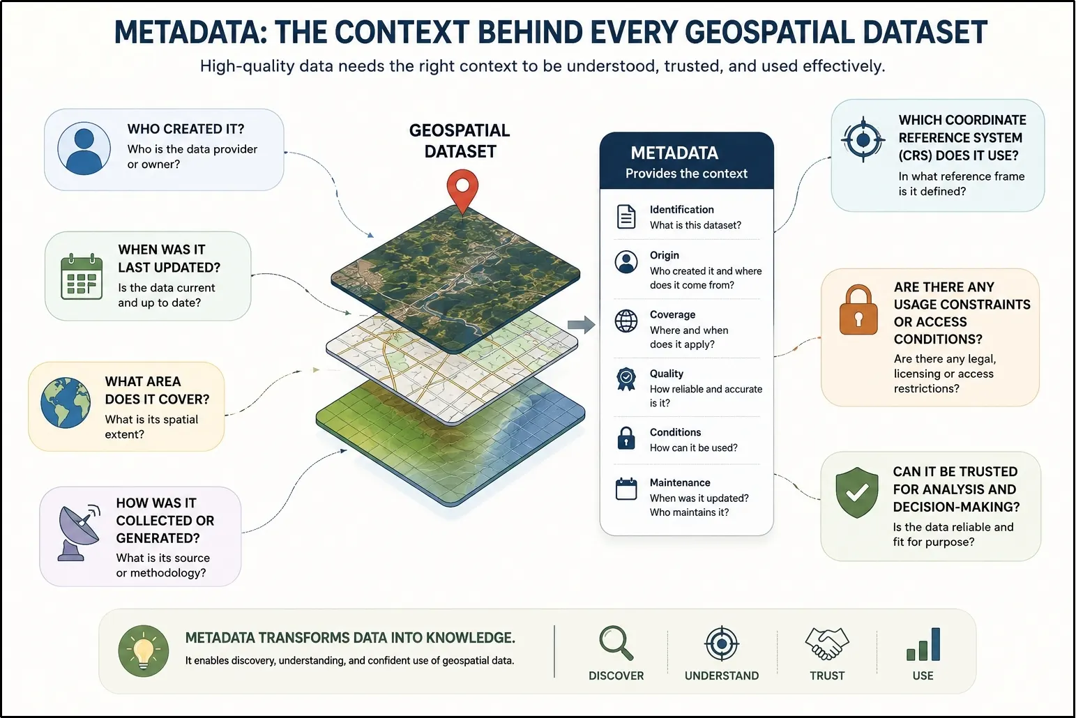
Figure 1: Critical contextual questions answered by metadata (Image created using AI)
The Integrated Geospatial Data-sharing Interface (GDI) is a standards-based platform for geospatial data discovery and exchange. To promote interoperability, transparency, and reuse, GDI embeds metadata directly into the data lifecycle, so contextual information stays attached to a dataset from the moment it is published through every time it is consumed.
Making Data Speak the Same Language
For metadata to be useful across organisations, it must follow a standard structure. In India, the National Spatial Data Infrastructure (NSDI) 2.0 Metadata Standard provides a common framework for describing geospatial datasets, enabling consistent discovery, sharing, and interoperability. While the internationally recognised ISO 19115 standard defines a comprehensive metadata framework comprising 343 metadata elements, its breadth makes direct implementation challenging across India’s diverse geospatial ecosystem, which includes government agencies, research institutions, academia, and industry. To encourage wider adoption while reducing the effort required for metadata creation, the NSDI 2.0 Metadata Standard defines a practical specification comprising 28 metadata elements, of which 9 are mandatory for every dataset. This ensures that essential metadata is consistently captured while allowing organisations to progressively enrich their records with additional information. Figure 2 illustrates how these core metadata elements are represented within the JSON-LD metadata structure. The NSDI 2.0 Metadata Standard is informed by and incorporates concepts from internationally accepted standards and specifications, including ISO 19115, OGC standards, FGDC, ANZLIC, and Dublin Core, enabling metadata to remain both practical for Indian organisations and interoperable with global geospatial ecosystems.
GDI currently maps the mandatory metadata elements prescribed by NSDI 2.0 (Table 1- Mandatory NSDI 2.0 Fields). To make metadata machine-readable and interoperable, GDI represents it using JSON-LD (JavaScript Object Notation for Linked Data), as shown in Figure 2. While a conventional JSON file organizes information as key-value pairs, the meaning of those keys is left to individual applications to interpret. JSON-LD extends JSON by introducing an @context, which maps each metadata element to standardized vocabularies and globally understood definitions. This allows different systems to interpret fields such as geometry, crs, or provider consistently, rather than relying solely on field names. As a result, search engines, applications, and metadata catalogues can automatically discover, understand, and reuse geospatial datasets without requiring custom mappings or manual interpretation.
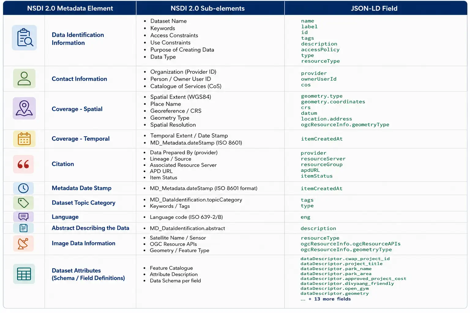
Figure 2: Mapping of NSDI 2.0 metadata elements to their corresponding JSON-LD fields implemented in GDI, illustrating how standardized metadata is represented in a machine-readable format. The red dashed box represents the mandatory NSDI 2.0 metadata elements and its respective sub-elements.
Metadata in Action: From Publishing to Discovery
Metadata only delivers value when it works for both sides of the geospatial ecosystem – the organisations publishing datasets and the users discovering and consuming them. GDI integrates metadata throughout this lifecycle, capturing it at the point of onboarding and keeping it available till the point of discovery.
For Data Providers: Metadata Captured at the Source
During dataset publication, providers are required to populate the mandatory metadata elements specified in NSDI 2.0 (Figure 2), ensuring that every published dataset contains the minimum information required for identification, discovery, and reuse. Additional metadata elements may be provided subsequently at the discretion of the data provider, allowing datasets to be enriched with more detailed contextual information over time. As GDI continues to evolve, the platform is progressively incorporating additional metadata elements to further align with the broader NSDI 2.0 specification and support richer dataset documentation (Figure 3).
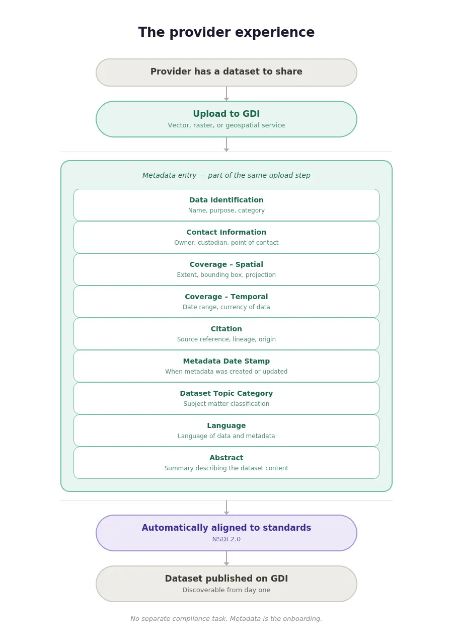
Figure 3: Metadata collection integrated into dataset onboarding.
For Data Consumers: Discovering the Right Dataset
On the discovery side, the GDI Catalogue lets users search and filter published datasets, then use the accompanying metadata to judge fitness for purpose before downloading anything (Figure 4). Once a dataset is selected, vector data is available as GeoPackages and raster or imagery data as GeoTIFFs, making the discovery-to-download workflow faster, more transparent, and more reliable.
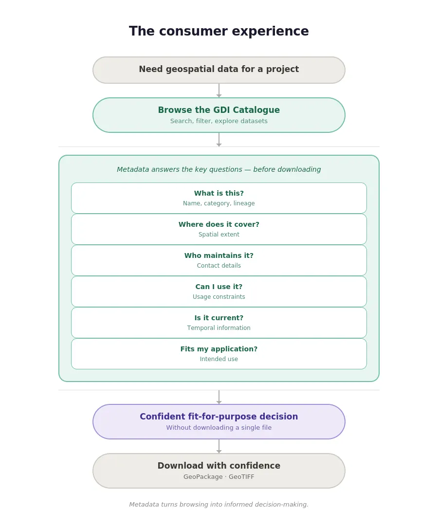
Figure 4: Metadata as an evaluation toolkit for data consumers.
Towards a Trustworthy Geospatial Ecosystem
As geospatial data grows in volume, variety, and complexity, metadata standards need to keep pace. ISO 19115 and NSDI 2.0 provide a strong foundation today, but emerging data types, real-time sensor streams, 3D city models, digital twins, and AI-ready datasets will demand richer, more expressive metadata. Technologies such as GeoAI and large-scale spatial analytics will increasingly depend on data that is well structured and well documented, making discoverability and interoperability essential to unlocking its full value.
By adopting nationally aligned standards today while staying adaptable to future metadata frameworks, GDI is building a geospatial ecosystem where datasets remain not just accessible, but meaningful, interoperable, and ready to support the next generation of geospatial applications.